Log in
All resources
Create a design
Tools
766 Free Images of Web Site
maps in the library of congress
la germanie inférieure de petrus keerius - c'est à dire- nouvelles et exactes cartes géographiques des xvii provinces dicelle
hishikawa school,ukiyo-e
tōkaidō bunkenzu - 1-bu o motte 1-chō ni ateru
expeditionis hispanorum in angliam vera descriptio anno domini mdlxxxviii
zehn karten und ansichten den schlachtfelden des amerikanischen unabhängigkeitskreiges in den staaten pennsylvanien und new york
a map of the british empire in america with the french and spanish settlements adjacent thereto
maps by claude joseph sauthier
claude joseph sauthier
maps by richard william seale
la germanie inférieure de petrus keerius - c'est à dire- nouvelles et exactes cartes géographiques des xvii provinces dicelle
maps in the library of congress
la germanie inférieure de petrus keerius - c'est à dire- nouvelles et exactes cartes géographiques des xvii provinces dicelle
maps in the library of congress
la germanie inférieure de petrus keerius - c'est à dire- nouvelles et exactes cartes géographiques des xvii provinces dicelle
maps in the library of congress
la germanie inférieure de petrus keerius - c'est à dire- nouvelles et exactes cartes géographiques des xvii provinces dicelle
maps in the library of congress
la germanie inférieure de petrus keerius - c'est à dire- nouvelles et exactes cartes géographiques des xvii provinces dicelle
maps in the library of congress
la germanie inférieure de petrus keerius - c'est à dire- nouvelles et exactes cartes géographiques des xvii provinces dicelle
maps in the library of congress
maps in the library of congress
1776 maps
la germanie inférieure de petrus keerius - c'est à dire- nouvelles et exactes cartes géographiques des xvii provinces dicelle
maps in the library of congress
la germanie inférieure de petrus keerius - c'est à dire- nouvelles et exactes cartes géographiques des xvii provinces dicelle
maps in the library of congress
la germanie inférieure de petrus keerius - c'est à dire- nouvelles et exactes cartes géographiques des xvii provinces dicelle
maps in the library of congress
la germanie inférieure de petrus keerius - c'est à dire- nouvelles et exactes cartes géographiques des xvii provinces dicelle
maps in the library of congress
la germanie inférieure de petrus keerius - c'est à dire- nouvelles et exactes cartes géographiques des xvii provinces dicelle
maps in the library of congress
la germanie inférieure de petrus keerius - c'est à dire- nouvelles et exactes cartes géographiques des xvii provinces dicelle
maps in the library of congress
la germanie inférieure de petrus keerius - c'est à dire- nouvelles et exactes cartes géographiques des xvii provinces dicelle
maps in the library of congress
la germanie inférieure de petrus keerius - c'est à dire- nouvelles et exactes cartes géographiques des xvii provinces dicelle
maps in the library of congress
la germanie inférieure de petrus keerius - c'est à dire- nouvelles et exactes cartes géographiques des xvii provinces dicelle
maps in the library of congress
la germanie inférieure de petrus keerius - c'est à dire- nouvelles et exactes cartes géographiques des xvii provinces dicelle
maps in the library of congress
la germanie inférieure de petrus keerius - c'est à dire- nouvelles et exactes cartes géographiques des xvii provinces dicelle
maps in the library of congress
la germanie inférieure de petrus keerius - c'est à dire- nouvelles et exactes cartes géographiques des xvii provinces dicelle
maps in the library of congress
maps in the library of congress
1777 maps of new york (state)
maps in the library of congress
1857 maps of pennsylvania
old maps of lycoming county, pennsylvania
maps in the library of congress
expeditionis hispanorum in angliam vera descriptio anno domini mdlxxxviii
maps in the library of congress
expeditionis hispanorum in angliam vera descriptio anno domini mdlxxxviii
maps in the library of congress
expeditionis hispanorum in angliam vera descriptio anno domini mdlxxxviii
maps in the library of congress
maps in the library of congress
1777 maps of new york (state)
expeditionis hispanorum in angliam vera descriptio anno domini mdlxxxviii
maps in the library of congress
expeditionis hispanorum in angliam vera descriptio anno domini mdlxxxviii
maps in the library of congress
zehn karten und ansichten den schlachtfelden des amerikanischen unabhängigkeitskreiges in den staaten pennsylvanien und new york
maps in the library of congress
maps in the library of congress
old maps of new jersey
expeditionis hispanorum in angliam vera descriptio anno domini mdlxxxviii
maps in the library of congress
expeditionis hispanorum in angliam vera descriptio anno domini mdlxxxviii
maps in the library of congress
expeditionis hispanorum in angliam vera descriptio anno domini mdlxxxviii
maps in the library of congress
maps in the library of congress
1713 maps
maps in the library of congress
old maps of france
maps in the library of congress
1863 maps
maps in the library of congress
old maps of latin america
a plan of the operations of the king's army under the command of general sr. william howe, k.b. in new york and east new jersey, against the american forces commanded by general washington, from the 12th. of october, to the 28th. of november 1776
maps in the library of congress
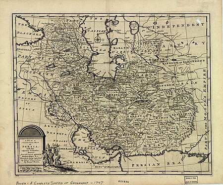
1747 persia map by emanuel bowen
maps in the library of congress
harmonia macrocosmica, seu, atlas universalis et novus, totius universi creati cosmographiam generalem, et novam exhibens - in quâ omnium totius mundi orbium harmonica constructio, secundum
maps in the library of congress
maps in the library of congress
1776 maps
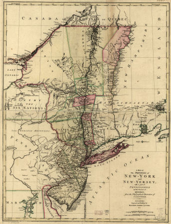
a map of the provinces of new york and new jersey, with a part of pennsylvania and the province of quebec
maps in the library of congress
harmonia macrocosmica, seu, atlas universalis et novus, totius universi creati cosmographiam generalem, et novam exhibens - in quâ omnium totius mundi orbium harmonica constructio, secundum
maps in the library of congress
harmonia macrocosmica, seu, atlas universalis et novus, totius universi creati cosmographiam generalem, et novam exhibens - in quâ omnium totius mundi orbium harmonica constructio, secundum
maps in the library of congress
zehn karten und ansichten den schlachtfelden des amerikanischen unabhängigkeitskreiges in den staaten pennsylvanien und new york
maps in the library of congress
maps in the library of congress
1610s maps of the world
maps in the library of congress
1763 maps of north america
zehn karten und ansichten den schlachtfelden des amerikanischen unabhängigkeitskreiges in den staaten pennsylvanien und new york
maps in the library of congress
maps in the library of congress
1776 maps of new york (state)
maps in the library of congress
1771 maps of north america
oswald walters brierly
f. jones
face tattoos in new zealand
te rauparaha
maps in the library of congress
1777 maps
maps in the library of congress
1791 maps
maps in the library of congress
1721 maps
zehn karten und ansichten den schlachtfelden des amerikanischen unabhängigkeitskreiges in den staaten pennsylvanien und new york
maps in the library of congress
zehn karten und ansichten den schlachtfelden des amerikanischen unabhängigkeitskreiges in den staaten pennsylvanien und new york
maps in the library of congress
maps in the library of congress
old maps of antigua and barbuda
a map of the british empire in america with the french and spanish settlements adjacent thereto
maps in the library of congress
zehn karten und ansichten den schlachtfelden des amerikanischen unabhängigkeitskreiges in den staaten pennsylvanien und new york
maps in the library of congress
zehn karten und ansichten den schlachtfelden des amerikanischen unabhängigkeitskreiges in den staaten pennsylvanien und new york
maps in the library of congress
zehn karten und ansichten den schlachtfelden des amerikanischen unabhängigkeitskreiges in den staaten pennsylvanien und new york
maps in the library of congress
a map of the british empire in america with the french and spanish settlements adjacent thereto
maps in the library of congress
heracles in humor
realism
crimean war by william simpson
sailing ships in art
a plan of the operations of the king's army under the command of general sr. william howe, k.b. in new york and east new jersey, against the american forces commanded by general washington, from the 12th. of october, to the 28th. of november 1776
maps in the library of congress
a map of the british empire in america with the french and spanish settlements adjacent thereto
maps in the library of congress
a map of the british empire in america with the french and spanish settlements adjacent thereto
maps in the library of congress
hms grinder (1855)
crimean war in art
maps in the library of congress
1744 maps of north america
maps in the library of congress
1755 maps of north america
maps in the library of congress
1771 maps of north america
a map of the british empire in america with the french and spanish settlements adjacent thereto
maps in the library of congress
a map of the british empire in america with the french and spanish settlements adjacent thereto
maps in the library of congress
maps in the library of congress
1771 maps of north america
maps in the library of congress
1755 maps of north america
maps in the library of congress
hishikawa school,ukiyo-e
maps in the library of congress
hishikawa school,ukiyo-e
maps in the library of congress
hishikawa school,ukiyo-e
maps in the library of congress
hishikawa school,ukiyo-e
maps in the library of congress
hishikawa school,ukiyo-e
maps in the library of congress
hishikawa school,ukiyo-e
maps in the library of congress
hishikawa school,ukiyo-e
maps in the library of congress
1763 maps of north america
maps in the library of congress
hishikawa school,ukiyo-e
maps in the library of congress
hishikawa school,ukiyo-e
maps in the library of congress
hishikawa school,ukiyo-e
maps in the library of congress
hishikawa school,ukiyo-e
maps in the library of congress
hishikawa school,ukiyo-e
a map of the british empire in america with the french and spanish settlements adjacent thereto
maps in the library of congress
a map of the british empire in america with the french and spanish settlements adjacent thereto
maps in the library of congress
maps in the library of congress
civitates orbis terrarvm
maps in the library of congress
1753 maps
builder
crane
maps in the library of congress
cartes et plans de l'amerique
maps in the library of congress
civitates orbis terrarvm
maps in the library of congress
1700 maps
cathedral school of st. john the divine
heins & lafarge
maps in the library of congress
civitates orbis terrarvm
maps in the library of congress
old maps of hungary
301 - 400 of 766
Next page
/ 8


![[Ten maps and views of the battlefields of the American Revolutionary War in the states of Pennsylvania and New York], 1777](https://cdn.creazilla.com/illustrations/10001550825/ten-maps-and-views-of-the-battlefields-of-the-american-revolutionary-war-in-the-states-of-pennsylvania-and-new-york-1777-sm.jpg)


![[Map of the defeat of the Confederate ship Alabama by the U.S. steamer Kearsarge on June 19, 1864, off Cherbourg, France].](https://cdn.creazilla.com/illustrations/10001534884/map-of-the-defeat-of-the-confederate-ship-alabama-by-the-us-steamer-kearsarge-on-june-19-1864-off-cherbourg-france-md.jpg)
![Winter quarters built by the rebels, now occupied by the 67th reg. P.V., 3d Brig., 3d Div., 3d Corps, A.P., [n]ear Brandy Station, Va., Louis N. Rosenthal, 1863](https://cdn.creazilla.com/illustrations/10001053331/winter-quarters-built-by-the-rebels-now-occupied-by-the-67th-reg-p-v-3d-brig-3d-div-3d-corps-a-p-n-ear-brandy-station-va-louis-n-rosenthal-1863-sm.jpg)


![[Ten maps and views of the battlefields of the American Revolutionary War in the states of Pennsylvania and New York], 1777](https://cdn.creazilla.com/illustrations/10000484458/ten-maps-and-views-of-the-battlefields-of-the-american-revolutionary-war-in-the-states-of-pennsylvania-and-new-york-1777-md.jpg)
![[Terrestrial globe gores]., 1615](https://cdn.creazilla.com/illustrations/10000787689/terrestrial-globe-gores-1615-md.jpg)

![[Ten maps and views of the battlefields of the American Revolutionary War in the states of Pennsylvania and New York], 1777](https://cdn.creazilla.com/illustrations/10001455242/ten-maps-and-views-of-the-battlefields-of-the-american-revolutionary-war-in-the-states-of-pennsylvania-and-new-york-1777-sm.jpg)


![[Ten maps and views of the battlefields of the American Revolutionary War in the states of Pennsylvania and New York], 1777](https://cdn.creazilla.com/illustrations/10001122410/ten-maps-and-views-of-the-battlefields-of-the-american-revolutionary-war-in-the-states-of-pennsylvania-and-new-york-1777-md.jpg)
![[Ten maps and views of the battlefields of the American Revolutionary War in the states of Pennsylvania and New York], 1777](https://cdn.creazilla.com/illustrations/10001450663/ten-maps-and-views-of-the-battlefields-of-the-american-revolutionary-war-in-the-states-of-pennsylvania-and-new-york-1777-sm.jpg)


![[Ten maps and views of the battlefields of the American Revolutionary War in the states of Pennsylvania and New York], 1777](https://cdn.creazilla.com/illustrations/10000506393/ten-maps-and-views-of-the-battlefields-of-the-american-revolutionary-war-in-the-states-of-pennsylvania-and-new-york-1777-md.jpg)
![[Ten maps and views of the battlefields of the American Revolutionary War in the states of Pennsylvania and New York], 1777](https://cdn.creazilla.com/illustrations/10000887733/ten-maps-and-views-of-the-battlefields-of-the-american-revolutionary-war-in-the-states-of-pennsylvania-and-new-york-1777-md.jpg)
![[Ten maps and views of the battlefields of the American Revolutionary War in the states of Pennsylvania and New York], 1777](https://cdn.creazilla.com/illustrations/10000597684/ten-maps-and-views-of-the-battlefields-of-the-american-revolutionary-war-in-the-states-of-pennsylvania-and-new-york-1777-sm.jpg)


